Wednesday, September 28, 2011

Travel to Spain (19th Century): An illustrated chronicle of its people and places

Gustave Doré (1832 – 1883) was a French artist, illustrator and sculptor but mainly one of the best engravers ever. One of his most famous works was the collection of illustrations for French edition of Cervante’s “Don Quixote”. Also the work he made to illustrate the Bible is well known. But the majority of Doré biographies never mention one of his most fascinating faces: he was a tireless traveller.


Gustave Doré was strongly influenced by 19th century European romantic tendence and his work served as inspiration for other artists like Van Gogh or Moebius.


In 1862 he made an initiatory travel to Spain and illustrated what he saw with extreme accuracy, visiting cities like Madrid, Toledo, Burgos, Sevilla, Valencia, the Alhambra of Granada… during the following years, he was releasing all the engraves regarding this travel, with Spanish monuments, city views and their people. He represented crafts (waterboys, merchants, barbers, peasants) poor and rich men, bullfights… even thieves and knife fights he saw. His human geography of Spanish gents in 19th Century really impressed me first time I saw it.

Gustave Doré wikipedia bio link here. Text is brief, but has a nice gallery with a complete list of works & references. Project Gutenberg has complete downloadable collection via FTP (I was really surprised about this) here. Arno Schmidt Reference Library has a direct link here to download "Illustrationen zu Don Quijote". It's a 24Mb pdf file with around 120 illustrations, so quality is fair.

Some samples below of his travel to spain;

Birds Hunting

Bullfighting on streets

Matador killed in bullfighting

Teresa Bolsi, female matador

Women at work (Sevilla tobacco manufacturing facility)

Public execution in Barcelona (using "garrote vil")


Fishermen playing cards

Contrabandist with his wife

Knife fighting on streets


Funeral with "jota" dancer and singer

Grand Escorial Palace (Madrid)

Port of Malaga

Sunday, September 25, 2011

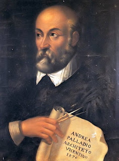
Quattro Libri dell'Architettura (The Four Books of Architecture, 16th Century)

This is probably the most ambitious treatise on Architecture ever published. Was composed by Andrea Palladio (1508-1580) in the Republic of Venetia and served as a reference for Architects all over Europe and America even nowadays. Palladio influence became fashionable all over Europe, for example in parts of the famous Loire Valley of France, Britain, Italy, Spain, and later to the new America, especially for Southern States cotton farms. In his Italian Journey, Johann von Goethe describes Palladio as a genius, commending his unfinished Convent of S. Maria della Carita as the most perfect existing work of architecture. Another Palladio admirer was the architect Richard Boyle also known as Lord Burlington, who, with William Kent, designed Cheswick House. The US Capitol building is an example of slightly evolved version of Palladio's works –a replica of this building exists also in Havana, Cuba-. Thomas Jefferson loved this style of architecture and considered also Andrea Palladio as a genius.
Andrea Palladio complete bio is available on the Wikipedia (very detailed), link is here. As a briefing, two remarkable facts: 1) He was strongly influenced by Roman and Greek Architecture (primarily by Vitruvius) and 2) He was incredibly prolific: see the Wikipedia reference list for all Villas, Palaces (Palazzos), Domes, Churches, Theaters and even bridges (pontes)… 


First Book has basics regarding choice of materials, rules of proportion, etc. Second Book has a compilation of projects with a specific description, third Book has specific guidelines for public buildings and infrastructures and fourth Book has a collection of ancient Roman temples, which has been used as a reconstruction of the archaeological remains and ruins of the immortal Rome.

Wednesday, September 21, 2011

Mercator's Atlas, 16th Century

Gerardus Mercator (1512-1524) is considered the father of the modern world atlas. Gerardus was a Cartographer that worked with his own collection of precision-mathematical instruments and also constructed several terrestrial globes, or armilar spheres (there are around 22 existing globes around the world, manufactured by Gerardus). All the persons –I include myself- that studied Oceanic Navigation know Gerardus Mercator because he introduced a revolutionary idea: the concept that a course can be established maintaining the same angle with all meridians crossed among starting and ending point with a single line, making very easy to obtain latitude and longitude (therefore position) with only speed and time of navigation. This method has some inconveniences at high latitudes, but is very accurate when navigation is near (and not so) to Ecuador.
Mercator developed the first detailed map of Palestina, in his "Atlas Cosmographicae Meditationes de Fabrica Mundi".

Gerardus Mercator
Some samples below from Mercator's Atlas. Please check America maps and consider that was discovered only 50-60 years before by Spaniards, thinking that they really arrived to Asia (Cipango) or Oriental Indias. Some details in North and South America cartography surprised me a lot, taking in account that exploration was intense in Central America and Cuba, but not so in other areas like north and south, at least during the first decades of 16th century.
Wikipedia link for Gerardus Mercator BIO (good enough!) is here. Have to say that I do not agree with some of the definitions and aspects provided in this link, like following sentence, which is located on wiki’s head: “This proved very useful to many later navigators who could (using his map) sail across the entire ocean on a straight path (called a rhumb line)”. Accurate description of Mercator principle has been defined in the first paragraph of this post (bold).
There’s a reference in Wikipedia for an online edition of Mercator’s Atlas (Britannica Online Encyclopedia) but doesn’t work: seems like the link is broken, at least I tried in 3 different locations without success. There’re some other online possibilities to admire Mercator’s Atlas like “turn-the-pages” digital editions but have the disadvantage that one must be internet connected...